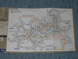
Maps make it much easier to get around Seoul and South Korea. First, you have find a map and you also need to make sure that it least part of it is in English or whatever your language may be. I found some maps at my local bookstore. One of the maps came inside the Lonely Planet's book, " on Seoul. This map was mainly a subway map. It is large enough for me to read and not too large that it is hard to open. This map helped me get to my destination every time. However, I didn't always get off at the right stop or take the correct exit from the subway. There is also a small map of Seoul on the back. I didn't use it at all. It didn't have enough detail.
지도 사용 하면 서울 및 한국 주위를 훨씬 더 쉽게 만들 수 있습니다. 첫째, 당신은 찾기 지도 하 고 또한 그것을 그것의 적어도 부분 영어 또는 귀하의 언어 일지도 모른다 무엇 이건이 되도록 해야 합니다. 내 로컬 서 점에서 일부 지도 발견. 지도 중 하나 "에 서울 론리 플래닛 책 안에 온. 이 지도 주로 지하철 지도 했다입니다. 그것을 읽고 나를 위해 충분히 큰 이며 하지 너무 큰 열 어렵다. 이 지도 사용 도와 때마다 내 목적지를 얻을 수 있습니다. 그러나, 나 항상 오른쪽 정류장 또는 지하철에서 올바른 출구를가지고 하지 않았다. 또한 뒷면에 작은 서울 지도가입니다. 모두 그것을 사용 하지 않았다. 그것은 충분 한 정보를 하지 않았다.
The second map, I got from the international map section at the same bookstore. It is huge, but it has a lot of detail. There are plenty of landmarks, street names, and business locations to guide you around the city. There is also a huge map of South Korea on the back side in case you plan on going somewhere else than Seoul. I unfolded this map to the section of the city that I was touring at the time. The large size really didn't get in the way. It really helped me find a lot of places that I never would have found without it.
두번째 지도 같은 점에서 국제 지도 섹션에서 있어. 그것은 거 대 한, 하지만 많은 세부 사항 있다. 건축물, 거리 이름 및 도시 주변 안내 비즈니스 위치의 많음이 있다. 또한 뒷면에 대한민국의 거 대 한 지도 경우 서울 보다 어딘가에 갈 계획입니다. 나는 난 시간에 여행 했다 도시의 섹션에이 지도 펼쳐 졌습니다. 큰 크기는 정말 방식에서 못해서. 또한 내가 결코 그것 없이 발견 했 장소를 많이 찾을 정말 줬.
I picked up a couple of maps at the tourist center in Suwon. Suwon is the largest town between Songtan, where I was staying, and Seoul. There is a huge historic castle and folk village there. I didn't make it there on this visit, but I will definitely be there on my next trip.The first map is a pretty good map of Suwon and the surrounding area. There is also a lot of information on the local tourist sites.
수원에서 관광 센터에서 지도 몇 집어. 수원 어디 나 체재 했다, 송탄와 서울 간의 가장 큰 마을입니다. 거 대 한 역사적인 성곽 및 민속촌 거기 있다. 이 방문 거기에서 그것을 하지 않았다 하지만 내 다음 여행은 확실히 거기 있을 것 이다.첫 번째 지도 수원 및 주변 지역 꽤 좋은 지도가입니다. 또한 지역 관광 사이트에 정보를 많이 있다.
The second map that I got from the Suwon tourist center was a map for the province that I was staying in. It is called Gyeonggi-do. It contains al of the area just to the south of Seoul, including Songtan. There is a pretty list of places to visit and a map to their location.
수원 관광 센터에서 이르렀다는 두 번째 지도 나에서 체재 하는 지방에 대 한 지도 했다. 경기도 라고 합니다. 송탄 등 서울 남쪽으로 단지 영역의 알을 포함 됩니다. 관광지를 방문 하 고 그들의 위치를 지도 꽤 목록이입니다.
.
The last map that I took with me was a map on the major historical sites in South Korea. It was given to me by a friend that worked at the South Korean consulate in Houston, Texas. She was at the graduation dinner for my beginning Korean language class. You can order this map on the internet or download it.
저와 함께 찍은 마지막 지도 한국에서 주요 역사 사이트에 지도 했다. 그것은 내게 휴스턴, 텍사스에 있는 한국 영사관에서 근무 하는 친구에 의해 주어졌다. 그녀는 내 시작 한국어 클래스의 졸업 저녁 식사 했다. 인터넷에이 지도 주문 하거나 그것을 다운로드할 수 있습니다.


No comments:
Post a Comment